GEOTECHNICAL ENGINEERING
WICHITA
HomeUnderground ExcavationsGeotechnical excavation monitoring

Geotechnical Excavation Monitoring in Wichita, KS

Rigorous testing. Clear reporting.

LEARN MORE

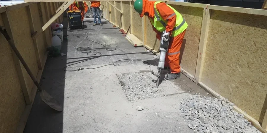
IBC Chapter 33 and ASCE 7-22 require a solid monitoring plan whenever an excavation exceeds 20 feet in depth, but in Wichita the real challenge hits sooner. The Permian shale and the unconsolidated alluvium along the Arkansas River create a sharp contrast in behavior: one wall stands near-vertical while the other starts creeping the moment you strip the topsoil. We deploy automated total stations and in-place inclinometers right from the first bucket cut, tracking lateral displacement against the 1-inch alarm threshold that most Kansas City-area insurers now demand. Because the water table east of the Arkansas sits barely 12 feet down, we also pair the monitoring array with in-situ permeability testing to anticipate bottom heave before it shows up in the readings.

Real-time monitoring is not about collecting data—it is about giving the superintendent a decision window before a 0.3-inch crack becomes a stop-work order.

Our service areas

Our approach and scope

A recent 45-foot excavation on East Douglas Avenue illustrated the issue clearly. The contractor expected stiff shale at minus 15, but hit a lens of saturated silt that had gone undetected during the initial borings. We installed a string of vibrating-wire piezometers behind the soldier pile wall and synced them with two automated total stations tracking prism targets on the adjacent historic façade. Within 48 hours the system flagged a 0.4-inch lateral drift and a 2-foot rise in pore pressure, which gave the shoring designer enough lead time to switch to a stiffer waler section without stopping production. When the stratigraphy is unpredictable, we frequently combine the excavation monitoring program with CPT testing to refine the soil profile during construction, because waiting for lab results from shelby tubes simply takes too long when the hole is already open.
Geotechnical Excavation Monitoring in Wichita, KS
Technical reference — Wichita

Local considerations

Wichita’s west side and the Riverside neighborhood sit on completely different foundations. West of I-235 you are dealing with the Wellington Formation—competent shale that gives a false sense of security until it weathers and slakes in the open air. Riverside, on the other hand, is built on 30 to 60 feet of alluvial sand and silt that behaves more like a beach than a building platform. An excavation in Riverside can lose 2 inches of ground behind the wall from dewatering alone, even if the structural deflection stays within spec. The real risk is not catastrophic collapse; it is the cumulative settlement that cracks century-old brick party walls, triggers neighbor claims, and stalls a project for weeks while lawyers trade letters.

Need a geotechnical assessment?

Reply within 24h.

Email: [email protected]

Reference standards

IBC 2021 Chapter 33 (Safeguards During Construction), ASCE 7-22 Section 12.13 (Geotechnical Monitoring), ASTM D6230 (Inclinometer Monitoring), ASTM D7299 (Vertical Inclinometer Probe), OSHA 1926 Subpart P (Excavations)

Typical values

ParameterTypical value
Lateral displacement accuracy0.04 in (1 mm) with automated total station
Inclinometer range±30° from vertical; 0.01 in/100 ft resolution
Piezometer typeVibrating-wire, 0-100 psi range
Settlement monitoringDigital level with invar staff, ±0.02 in closure
Crack meter resolution0.0004 in for adjacent structures
Alarm threshold (typical)1.0 in lateral / 0.5 in settlement
Reporting frequencyDaily PDF + SMS alert on exceedance
Reference standardIBC 2021 Chapter 33, ASCE 7-22 Section 12.13

Frequently asked questions

When does IBC Chapter 33 require excavation monitoring in Wichita?

The 2021 International Building Code triggers a monitoring plan for excavations deeper than 20 feet, or shallower cuts that underpin adjacent structures. In practice, the Wichita building official often requires instrumentation for any excavation within the Arkansas River floodplain, where the alluvial soils and high water table elevate the risk of off-site movement.

What does geotechnical excavation monitoring cost for a typical Wichita project?

Budgets generally fall between US$790 and US$2,840 per month depending on the sensor count and reporting frequency. A basic setup with two inclinometer casings, a few settlement points, and weekly manual readings sits at the lower end, while a fully automated system with total stations, wireless piezometers, and daily interpretation reaches the upper range.

How fast can you install instrumentation once the excavation starts?

We mobilize within 48 hours of the notice to proceed. Inclinometer casings are grouted into boreholes behind the wall line before the first bench cut, and surface monuments are set the same day. Automated total stations require a stable reference pillar, which we cast and cure in three days using high-early-strength grout.

Who receives the monitoring data during the excavation?

The daily report goes to the shoring designer, the general contractor’s superintendent, and the owner’s representative. If any parameter exceeds 80 percent of the design alarm threshold, the system sends simultaneous SMS and email alerts so the team can assess whether the exceedance is a trend or an isolated event before the next shift starts.

Location and service area

We serve projects in Wichita and surrounding areas.

View larger map